
Summer Hiking in Arosa
You lace up your boots at valley level in Arosa, step onto a marked trail, and within three hours you're standing at 2,900 metres above sea level with the entire Grisons spread out below. The trail network here spans over 200 kilometres across the Arosa Lenzerheide region, connecting forested paths with high alpine routes that zigzag between crystal-clear mountain lakes. What sets this valley apart is what it lacks: the crush of day-trippers, the queue for the cable car, the sense that you're following a prescribed tourist route. Arosa remains an insider tip among Swiss mountain destinations, and nowhere is that more apparent than on the trails.
The hiking here suits everyone from families with young children to experienced alpinists planning multi-day ridge traverses. You might start your morning on the Squirrel Trail, designed for short legs and curious minds, then spend the afternoon ascending Weisshorn, the valley's highest peak. The trails rarely feel crowded. You encounter chamois on rocky outcrops, marmots whistling from boulder fields, and the occasional golden eagle tracing thermals above the ridgeline.
What Summer Hiking in Arosa Involves
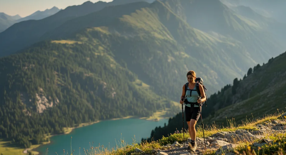
You step onto Route 766 just after breakfast, following red-and-white waymarks that lead toward Weisshorn. The first section winds through forest where the air stays cool even on warm summer days. After 40 minutes the trees thin and you emerge onto an alpine meadow where cows graze, their bells clanging irregularly in the stillness. The path steepens here, switching back across open slope where wildflowers cluster: alpine roses, gentians, edelweiss in the rockier sections.
You gain elevation steadily. The physical work becomes meditative, breath and footfall syncing into a pattern that lets your mind wander. Views open behind you (the valley floor with its scatter of chalets, Obersee reflecting morning light, the opposing ridges layering into blue distance). Higher up, the vegetation disappears and you're walking on scree and exposed granite. The summit plateau arrives unexpectedly after one final steep pitch. At 2,653 metres, Weisshorn offers panoramic views that stretch to peaks you recognize from maps and others you don't.
The descent takes different muscles. Your knees absorb the downhill momentum on the well-maintained path. You pass other hikers heading up, exchange brief greetings in German and Italian and English. By mid-afternoon you're back in the forest zone where shade and the sound of running water mark the final kilometres to the valley.
Themed Routes and Family Trails
The trail network includes paths designed around specific themes. The Squirrel Trail near Maran leads through forest habitat where red squirrels are commonly spotted, with information boards explaining their behaviour and ecology. The route covers 3 kilometres with minimal elevation gain, manageable for short legs while keeping young hikers engaged.
Near Litzirüti, the Bear Sanctuary adventure trail connects with the wildlife park, where rescued brown bears live in spacious alpine enclosures. The trail combines wildlife observation with information about bear conservation and the history of bears in the Swiss Alps.
The Lucky Stone Trail and Trail of the Planets take different approaches. The former incorporates local folklore and Grisons cultural traditions into the walking experience, with installations explaining the stones' supposed properties. The latter translates astronomical concepts into walkable distance; each step represents thousands of kilometres of space. These themed routes make experiences arosa accessible to visitors who want structure and narrative alongside the physical activity.
The Ten-Lake Hike
The signature route in the valley connects ten mountain lakes across 15 kilometres of varied terrain. Start at Prätschli, where the Untersee sits at 1,691 metres, its surface calm enough on still mornings to mirror the surrounding peaks perfectly. The trail climbs gradually toward Alteinsee, smaller and more secluded, tucked between ridges where the forest hasn't yet given way to alpine grassland.
Each lake occupies a different elevation and microclimate. Some freeze until late June; others warm enough for brave swimmers by August. The crystalline clarity of the water reveals every stone on the bottom. At Schiesshorn, the trail reaches its highest point before descending past additional lakes, each with its distinct character.
The route takes six to seven hours at a steady pace, with minimal technical difficulty but sustained elevation changes that require reasonable fitness. The hike works as a day trip from hotel arosa, or you can split it across two days using the mountain huts that dot the higher elevations.
High Alpine Routes
Beyond the well-trafficked paths lie routes that demand more technical skill and mountain experience. The Schiesshorn circuit climbs above 2,600 metres, crossing permanent snowfields and exposed ridgelines where cable-assisted sections help hikers navigate steeper pitches. Weather matters here; afternoon thunderstorms develop quickly in the alpine zone during summer. Start early, watch the sky, and turn back if conditions deteriorate.
Route options extend into multiday traverses when you combine Arosa's trails with the connected Lenzerheide network. The total system reaches nearly 300 kilometres of marked paths. You can plan loops that link mountain huts, spending nights at 2,400 metres with minimal amenities but maximum atmosphere. Book hut reservations well in advance during July and August when demand peaks.
Technical routes require proper equipment: boots with ankle support, trekking poles for stability, layers including rain gear, map and compass or GPS device, and emergency supplies. The Swiss Alpine Club publishes detailed route descriptions that include current conditions, difficulty ratings, and estimated times.
Wildlife and Natural Encounters
The animal sightings happen when you pay attention and move quietly. Chamois prefer rocky terrain above the tree line; look for them on cliff faces and scree slopes during morning and evening hours when they feed most actively. Marmots inhabit boulder fields and alpine meadows, their whistles serving as alarm calls when predators approach.
Red deer and ibex occupy different niches in the ecosystem. Deer stay lower, in the forest-meadow transition zone, while ibex seek the highest, most precipitous terrain. You might spot them as distant silhouettes on ridgelines, or encounter them surprisingly close when a male ibex allows his curiosity about humans to overcome his natural wariness.
Birds of prey patrol the thermals. Golden eagles hunt marmots and grouse; peregrine falcons take smaller birds in spectacular diving stoops. The bird life shifts with elevation: nutcrackers and crossbills in the conifer zone, alpine choughs and snow finches above tree line, water pipits along the streams that feed the lakes.
Practical Considerations
Trail conditions vary through the summer season. Snow lingers at higher elevations into June, blocking some routes until the melt progresses. July and August offer the most reliable access to high alpine trails, with wildflowers peaking in mid-July. September brings autumn colours and fewer crowds, though weather becomes less stable.
Cable cars provide access to higher starting elevations, reducing the total ascent required for peak routes. Check operating schedules and weather forecasts before heading out; the first cable car typically departs around 8:30 AM, and the last descent runs around 5:00 PM.
Temperature differences between valley and summit can reach 15-20 degrees Celsius. Layer your clothing: a base layer that wicks moisture, an insulating mid-layer, and a weather-resistant outer shell. Carry extra insulation for summit breaks when you stop moving and the wind cuts through sweaty base layers.
Water sources exist along most trails, though carrying a filter or purification tablets makes sense if you plan to drink from streams. Aim for a litre per three hours of moderate hiking, more in hot conditions or on strenuous climbs.
How Arosa Functions as a Hiking Base
The valley's compact size means trails begin within walking distance of lodging. You don't need a car to access trailheads; the local bus system connects villages and cable car stations efficiently. The hiking infrastructure shows Swiss precision: trails are graded and maintained consistently, signage uses the standardized yellow diamond system, and estimated times posted at junctions prove remarkably accurate.
After a day on the trails, wellness arosa offerings address the specific fatigue that comes from mountain walking. The spa arosa facilities include saunas that ease muscle tension, pools at varying temperatures that aid circulation, and treatment options targeting the specific complaints of active guests.
The dining scene accommodates appetites sharpened by mountain air. Traditional Grisons cuisine appears on menus: barley soup, Bündnerfleisch, Capuns. The portions satisfy hikers' caloric needs. Local wines from the Grisons valleys pair with the food.
Extending Your Mountain Experience
The trail network connects with the broader what to do arosa options that fill non-hiking days or half-days when weather turns poor. The village offers enough variety that you can spend a week here and never repeat an activity: climbing walls, via ferrata routes, mountain biking trails, the lake for swimming and paddleboarding.
Consider mixing difficulty levels through your stay rather than attempting the hardest routes every day. Alternate a strenuous peak ascent with an easy valley walk; your body performs better when allowed recovery time between major efforts. The themed trails and lake walks provide this balance.
The quiet that drew you to Arosa in the first place deepens on the trails. You might encounter a dozen other hikers on popular routes like Weisshorn, fewer than that on side valleys and less-travelled peaks, sometimes none at all on the network's more remote corners. The solitude isn't absolute, but it's genuine. You walk for hours with only the sound of your breathing, your footsteps, the wind, the occasional bird call. That's what people mean when they call Arosa an insider tip: the mountains here haven't been marketed into overcrowding.
Hotel Altein serves as an ideal base for exploring Arosa's extensive trail network. Located in the heart of the valley, the hotel provides comfortable accommodation and recovery amenities after long days in the mountains. Guests can easily access trailheads on foot or via the nearby bus connections, returning each evening to the hotel's wellness facilities and dining options. The staff can provide trail recommendations, weather updates, and assistance with planning your hiking itinerary throughout the region.
Frequently Asked Questions
How extensive is the hiking trail network around Arosa?
The trail network spans over 200 kilometres across the Arosa Lenzerheide region. Combined with the connected Lenzerheide network, the total system reaches nearly 300 kilometres of marked paths. Trails connect forested paths with high alpine routes between mountain lakes.
Who is summer hiking in Arosa suitable for?
It suits everyone from families with young children to experienced alpinists planning multi-day ridge traverses. Themed and family routes include the Squirrel Trail near Maran, which covers 3 kilometres with minimal elevation gain. High alpine routes such as the Schiesshorn circuit climb above 2,600 metres and demand more technical skill.
What is the Ten-Lake Hike?
It is the signature route in the valley, connecting ten mountain lakes across 15 kilometres of varied terrain. It takes six to seven hours at a steady pace, with minimal technical difficulty but sustained elevation changes requiring reasonable fitness. You can do it as a day trip or split it across two days using the mountain huts at higher elevations.
When is the best time for summer hiking in Arosa?
July and August offer the most reliable access to high alpine trails, with wildflowers peaking in mid-July. Snow lingers at higher elevations into June, blocking some routes until the melt progresses. September brings autumn colours and fewer crowds, though weather becomes less stable.
How does Altein, Arosa work as a hiking base?
The hotel is located in the heart of the valley, and trails begin within walking distance of lodging. Guests can access trailheads on foot or via nearby bus connections, so you do not need a car. Staff can provide trail recommendations, weather updates and help planning your itinerary, with wellness facilities for recovery after long days.